3. Earth texture
The texture used to cover the surface of the "Surface" sphere is the most complex and it gives a good example of the power of the material editor of MAX.
The only relevant basic parameter used is glossiness that defines how shiny the globe looks. It is set to a medium value of 40. The specular level is overridden by a specular map.
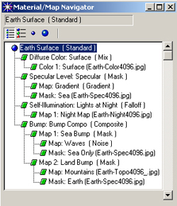 Let's explore the components of this texture through the Material/Map Navigator.
Under Tools > Material Editor, In the material Editor window, I selected the first material ("Surface") and by clicking on the Material/Map Navigator icon (2 blue balls connected by a dotted line) I get the window on the left here.
The first element in the list is "diffuse color". This channel is used to define what is visible on the areas of the sphere that are in the (sun)light, i.e. the image of seas and continents.
But the real color of water, earth, forests, etc. needs to be altered to take into account the atmospheric effect.
We need to add some blue to the image. This is why the diffuse map is made out of a "mix" material with 2 components: the picture of the ground (Earth-Color4096.jpg) and the colour blue. Mix Amount specifies 15% of blue added to the picture.
The second element is the specular level that defines how the material reacts the highlight of the spotlight (the Sun) itself. Water is shiny and earth is not shiny at all. Moreover, the closer the specular highlight is to the horizon, the more intense the reflection is.
A mask is used to prevent the continents from displaying a specular highlight (typical behavior of matte materials like earth). I used a black & white image of the surface of Earth. By convention, the white areas (the continents) are masked and the black areas (seas) "show through". Now for the seas, the specularity described above can be represented by a radial gradient with low specularity at the centre of the sphere and higher reflection of the Sun on the border. Therefore the specularity map is a gradient material, black at the centre and grey on the outside.
The third element will describe the self-illumination of the globe when it is not under direct light, resulting from artificial lighting of the cities or the oil wells in the Persian Gulf. The very powerful Falloff map is used here with the "shadow/light" parameter selected. Falloff generates a map based on the illumination of the scene.
I set it up to do nothing in the lit areas and to display the Nasa night map in the shadow areas.
Finally, the last element defines the bumpiness of the surface of the sphere. Once again, sea and land must be considered separately. The bumpiness of sea is defined by waves and the bumpiness of the land is defined by the mountains.
Sea and land are treated separately and then composited to provide the final result.
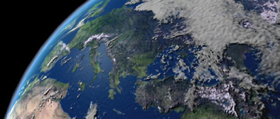
Sea first. The same mask is used as for the specular effect to avoid creating waves on land. The waves are simply a turbulent noise material of very small wavelength. The result when rendering is very small dots in the specular highlight on the surface of the sea (see picture below).
Now land. The image provides the necessary elevation information, white for high, black for low. No need for a mask here because seas are all black in the image. In the output panel, bump amount has to be set to 0.5 (instead of 1) to approximate the real height of Earth's mountains and not end up with unrealistic terrain.